
Note: It’s been awhile since I have blogged due to getting up to speed at a new job, but I’ve been adventuring all summer on the weekends with many routes that I hope to share over the coming months. For more “instant” content, see the sidebar below for Instagram photos.
The Trinity Alps High Route in 2015 was a tremendous fastpack experience, and while I come back to the Trinities regularly, I was overdue for a return to fastpacking the high route after three seasons. Rather than repeat the trek from three years ago I used a different starting trailhead (Caribou Lakes Trail) and designed a substantially different loop to include some additional scenery along the way, including Emerald and Sapphire Lakes, Kalmia Lake, L Lake, and the high traverse between Caesar Peak and Caribou Lakes. This year’s loop included more lakes, but less summits skipping Sawtooth Mountain and Mount Hilton. However, in terms of scenery the configuraturation from this year was even better than 2015 and shows that there is no one right way to do the Trinity Alps High Route. This trip was completed at the end of June, but I’ll be following up with a couple more recent adventures in the Trinity Alps. Complete photo album here. Route map here.


Intro on the Trinity Alps High Route: The Trinity Alps are a spectacular and rugged collection of mountains and ridges tucked deep in the Klamath Mountains of Northern California. Largely overlooked for the neighboring greater ranges in the Sierra Nevada and Cascades, these mountains remain a gem where solitude and adventure can be found in a large expanse of trail-less wilderness. In fact, as the Trinity Alps are geographically between the Cascades and the Sierra, the mountains contain a magical blend of both range’s characteristics. One of my favorite aspects of the Trinities is the wonderful diversity of conifers including various species of pine, fir, hemlock and the whimsical Brewer’s weeping spruce. The Trinity Alps High Route (TAHR) was conceived by Deems Burton after extensive exploration learning the intricacies of this wild terrain. The high route is characterized by ubiquitous white granite, serene alpine lakes, and clumps of picturesque krummholz. It is said that the ubiquitous white granite of these mountains produces an incomparable deep blue sky and I’d have to agree.


Key Gear Used:
- La Sportiva Akasha, my go-to adventure shoe over thousands of miles. I trust the Akasha for its ability on technical terrain and comfort while on my feet all day long.
- Ultimate Direction Fastpack 25, everything you need for a couple night fastpack. This update from the Fastpack 20 rides better, includes collapsible pole holders up front, and a very useful interior pocket for key items.
- Ultimate Direction FK Bivy, kept me warm, and most importantly, kept the bugs out allowing me to sleep in peace!
- La Sportiva Mountain Running Apparel, including the Action Longsleeve, Freedom Tight short, and Nucleus Tight

Rather than go into the details of every step of the route I’ll focus on the features of this loop that I did not include on the route from 2015.
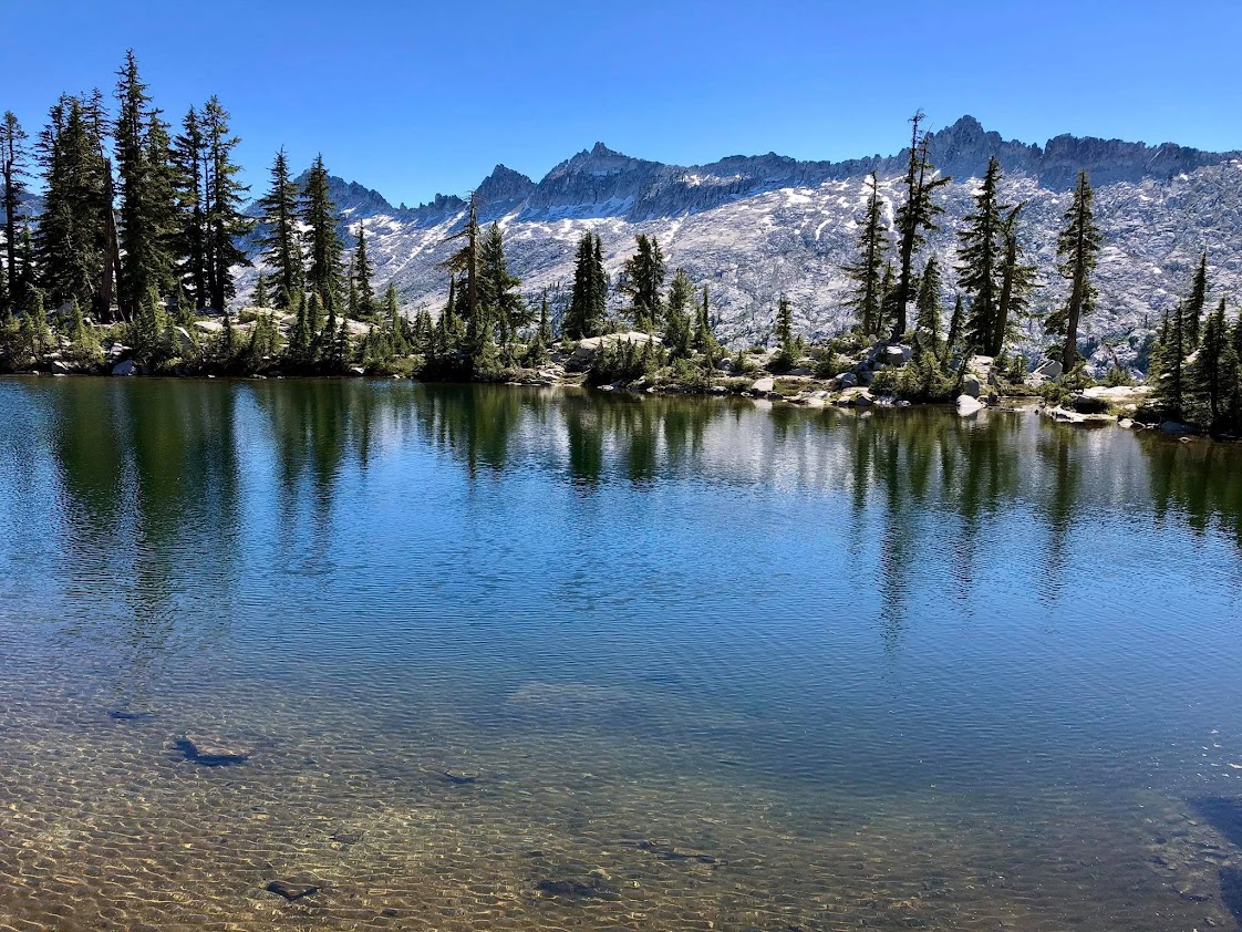
Kalmia Lake: The spectacular Kalmia Lake hangs above cliffs that tumble down to upper Canyon Creek. Depending on your perspective this is a small lake or a large tarn. The lake itself is neither deep nor particular inviting for swimming but it’s position is stunning with views across the canyon to the serrated ridgeline from Mount Hilton to Wedding Cake to Thompson Peak. To reach Kalmia Lake make a gradually ascending traverse from Kalmia Pass through old growth mountain hemlock forest and round a corner into the small Kalmia Lake basin. Descend easy slopes to the lakeshore. One can travel north along the ridge moving toward Caesar Peak for breathtaking views down to Mirror, Sapphire and Emerald Lakes. From Kalmia Pass to L Lake generally head straight down through open forest. When the surrounding terrain turns brushy keep descending a (usually) dry rocky gully that avoids all brush. The rocks are large and generally stable with a few sections of scrambling. Eventually leave the rocky gully to the left for grassy, wet meadows which lead down to the creek that flows out of L Lake. On the other side of the creek the use path from Canyon Creek Lakes to L Lake can be picked up.


Canyon Creek Lakes up to the “Granite Highway”: One of the most enjoyable parts of the Trinity Alps High Route is a 2 mile stretch of travel on ice-polished granite slabs from the northeast ridge of Mount Hilton to “Man on Rock Pass” near the Wedding Cake. The amazing stretch of relatively easy off-trail travel has views in every direction and travels underneath a set of jagged spires. In order to access this stretch from Canyon Creek Lakes, one might assume that a circuitous route around the east side of Upper Canyon Creek Lake is required. However, a more direct and efficient route is to traverse the west shore of Upper Canyon Creek lake and then ascend talus and a short steep section to the ridge. Upon reaching the ridge look back at an amazing view of the Canyon Creek Lakes below. Ascend the granite ridge, now more moderately sloped, amid a wonderful grove of Brewer’s Weeping Spruce. The spruce transition to mountain hemlock above 6,500. Enjoy the fantastic views of the upper Canyon Creek watershed. At around 6,800 leave the ridge and make a long ascending traverse on granite slopes to about 7,500 where a gorge can be crossed joining up with the “Granite Highway” to Man on Rock Pass.


Grizzly Lake: In 2015 I arrived at Grizzly Lake as the sun was setting and left as the sun rising. In addition, the amazing waterfall at the outlet had already slowed to a trickle in September. While still beautiful, Grizzly Lake did not reach its potential. This time I was there much earlier in the season so the waterfall was flowing strong and leaping off the cliffs. I also timed the route so that I would be descending to Grizzly Lake in late morning and departing in early afternoon when the sun showcases the lake’s magical blue and turquoise colors. Grizzly Lake sees a lot of visitors which detracts from the wilderness experience, but virtually everybody stays in the vicinity of the lake outlet and solitude can soon be found when venturing above the lake along the high route. Suitable camping spots are limited to near the outlet and unfortunately many of the spots people chose to camp are much too close to the lakeshore. In addition, fuels for campfires are EXTREMELY limited to non-existent as vegetation is sparse and virtually all dead wood has already been burned by previous visitors. If you must camp at Grizzly Lake, please avoid making a campfire and respect the fragile environment around the lake.


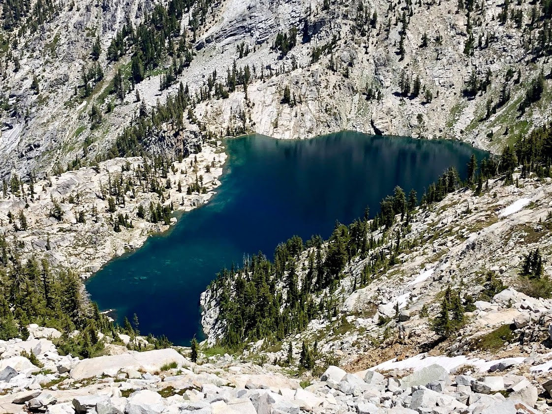
Caesar Peak to Caribou Lake: This section of the route passes through the very remote drainages on the north side of Sawtooth Ridge between Caesar Peak and Peak 7905. This part had the most uncertainty as no information could be found on its feasibility. Staying on the Sawtooth Ridge crest would be aesthetically appealing, but it looks arduous and time consuming with many pinnacles, some brush and lot of fluctuation in elevation. The more efficient route stays on the north side of Sawtooth Ridge and makes a gradually descending traverse from the pass separating Grizzly Lake from the Little South Fork watershed. Friendly granite slabs transition to wonderful meadows with alpine tarns and small waterfalls. The serrated ridgeline of Sawtooth Ridge looms above. Traverse high above Little South Fork Lake at around 6,800 feet before descending to a small tarn at the headwaters of Little South Fork. The tarn is positioned in a rugged cirque ringed with cliffs and clumps of mountain hemlock. On my visit in the afternoon the tarn had an ethereal emerald color which was an unexpected treat. From the tarn one can easily descend to Little South Fork Lake or Moraine Lake. To continue the traverse toward Caribou Lakes ascend steep slopes to a notch on the north ridge of “Point 7,400+,” which is a rugged feature along Sawtooth Ridge. Point 7400+ and its ridge seem like an impasse to easy travel but the notch at ~7,200 ft conveniently allows passage into the Middle Fork Little South Fork drainage. On the east side of the notch are a few scramble moves to reach easy slopes below. Traverse more granite slopes and then shady woodland to a small lake at the headwaters of the Middle Fork. From this small lake one last climb remains up to Peak 7905. Friendly granite slabs and meadowy terrain make this an efficient climb. Peak 7905 has one of the best vistas in into the heart of the Trinity Alps including an amazing bird’s eye vantage of Emerald and Sapphire Lakes. From Peak 7905 a use trail leads down the ridge where the Caribou Scramble Trail can be picked up.


This year’s Trinity Alps High Route was fantastic. Perhaps the ultimate route would include another day for a climb of Sawtooth Mountain and visits to Smith and Morris Lakes and perhaps even Alpine Lake. This year’s route also missed the wonderful Boulder Creek Lakes and the lovely Papoose Lake, but it would be virtually impossible to see it all in one aesthetic loop. All the more reason to come back for more fun on the Trinity Alps High Route!


We know you are a stud but quit posting off trail routes in the Trinities. Let courageous folks discover them on their own. That is best for all.