
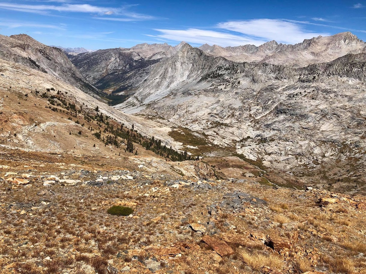
Glacier Ridge is a massive granitic formation separating Deadman Canyon and Cloud Canyon, two spectacular glacial canyons with a signature U-shape. The ridge spans an impressive 8 miles and towers over 4,000 feet above the canyon bottoms. The high point along the ridge is 1.4 miles north of Copper Mine Pass Peak and provides arguably the best view of the northern half of the Great Western Divide from the west (or anywhere). The summit is also positioned for a dramatic birds-eye view of both Deadman Canyon and Cloud Canyon, which almost surround the high point. The position of these canyons west of the Great Western Divide and north of the Kings Kaweah Divide enables maximum orographic enhancement during winter storms making this region one of the snowier spots in the Southern Sierra. It’s no wonder that the glaciers in these canyons were once so big and dug such deep canyons! Complete photo album here (or Facebook Album). Route taken here.


Glacier Ridge is known as one of the more remote peaks in the High Sierra with the vast majority approaching via Marvin Pass, Roaring River and Cloud Canyon, a route that is mostly on trail but adds up to nearly 50 miles roundtrip. A shorter and much more scenic and rewarding route follows the Skier’s Sierra High Route from Wolverton up to the Tablelands and on to the highest reaches of Deadman Canyon. From Deadman Canyon a fortuitous corridor through steep slabs on the west side of Glacier Ridge enables relatively easy access to the ridge crest and the final scramble to the summit. Instead of the long trail miles under forest canopy on the standard approach, this route has a relatively brief section of trail followed by efficient off-trail travel with spectacular vistas. However, even this “shorter” route is still close to 16 miles each way from Wolverton, and the off-trail travel, while relatively easy, will still require more attention and effort than hiking or running a trail.


Starting at Wolverton, take the Pear Lakes Trail to Pear Lake ranger cabin. At the ranger cabin, angle up and to the north into the Marble Fork Kaweah River drainage. After mid season the Marble Fork is totally dry but in early season one may have to stay on the south side of the river until much higher up the canyon. Either way, both sides of the river provide efficient granite slabs up to Table Meadows. Continue climbing easy slabs above Table Meadows almost due east to near the crest of the Tablelands. It may seem tempting to cut south toward Pterodactyl Pass prematurely (as I did), but complex, undulating terrain largely negates any distance savings. From the crest of the Tablelands, either traverse to Pterodactyl Pass, which is located 0.5 mile south of Big Bird Peak, or ascend the ridge up to the summit of Big Bird Peak. Big Bird Peak is relatively easy to traverse and the descent off its east side is a plunge step with only modest elevation loss to reach Lonely Lake. Moreover, the view from Big Bird Peak to the Kaweahs, Great Western Divide and Big Bird Lake is absolutely stunning. I would recommend Big Bird Peak if taking the route over to Lonely Lake and Fin Pass. If descending to the Elizabeth Pass Trail to utilize the trail to Elizabeth Pass I would recommend Pterodactyl Pass.


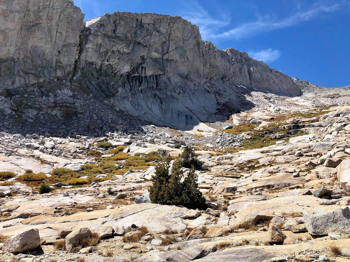
Either way, once in the upper reaches of the Deadman Canyon drainage relatively easy cross country travel continues. From Fin Pass it’s over 2 miles traversing around the headwall of Deadman Canyon to the base of the route up Glacier Ridge. The climb up the west side of the ridge looks technical from afar with intimidatingly steep slabs, but a weakness in the slabs provides a steep corridor of mostly class 2 scrambling up to the ridgeline. Be careful to not descend too soon as cliffs and brushy terrain await below. Instead, it is best to round the canyon headwall and then make a gradual descent to ~11,00 feet. Once beneath the west face of Glacier Ridge, continue traversing northwest on talus between two cliff bands as the slope angle above and below steepens considerably. Eventually the talus ends, but looking up and to the right reveals a weakness in the steep slabs with patches of grass, dirt and rocks allowing relatively easy passage through this steep section of slabs. This corridor is fairly straight, and straying from the corridor could get into some steep class 3 and 4 slab climbing. When one reaches clumps of whitebark pine the slope angle lessens and the remainder of the climb up to the ridge crest is largely a sand and a talus slog. The ridgeline is relatively easy to cross over at the low point south of the Glacier Ridge peak. Once over the ridge, traverse to the right hand chute on the south side of the Glacier Ridge high point. This chute is also class 2 and serves as the finish for the standard route. Avoid taking the left slope closer to the ridge crest as this slope ends on wrong side of the summit block. The highest point is a large balanced boulder with large knobs on the north side to assist with climbing. It is rated as class 4 with some exposure off to the south, but the rocks immediately beneath the boulder are fairly flat reducing the threat of falling off.


From Glacier Ridge one can continue to the Whaleback, Colby Lake and beyond, or simply return back to Wolverton. For a simple return one can either retrace steps back into Deadman Canyon via the west face route or make a lollipop loop by including Copper Mine Pass Peak. For the alternative via Copper Mine Pass Peak, descend Glacier Ridge to about 11,000 feet in Cloud Canyon before beginning a traverse and ascent toward Copper Mine Pass Peak. This alternative return route is longer with more elevation gain, but provides some spectacular new vistas of Cloud Canyon. In addition, Copper Mine Pass Peak is a fantastic viewpoint with jaw dropping views toward the Kaweah Ridge, Great Western Divide and both Cloud and Deadman Canyons. From the point where one rounds a prominent buttress at ~11,000 feet, the ascent up to Copper Mine Pass Peak is straightforward.


Reach the Kings-Kaweah divide at about 12,200 feet finding remnants of an old mining path that cuts across the rocky, shale slope. Make sure to leave the path and ascend the final few feet to the summit of Copper Mine Pass Peak and enjoy the wonderful view. As a note, I can’t see a situation where I would use “New” Copper Mine Pass, which is the low point north of Copper Mine Pass Peak (aka “Old” Copper Mine Pass) instead of this straightforward ascent up Copper Mine Pass Peak with its lovely views. From Copper Mine Pass Peak, this old miners path becomes more defined and descends to the saddle west of the peak. After a few switchbacks down from the ridge crest some artifacts of the mine can be found before the old path fizzles out in the easy granite slabs characteristic of the upper reaches of Deadman Canyon. Traverse slabs with some embedded talus hopping to Fin Pass or Elizabeth Pass, where the exit will retrace the approach.


Great routes and photos! The Strava route for this one seems to have disappeared. Any chance of somehow correcting or reloading? Thanks!