
With the unreasonably long closure post-Soberanes Fire finally over, it was time to return to Ventana Double Cone. If Cone Peak is the King of the Big Sur Coast, Ventana Double Cone is the Queen of the Ventana Wilderness. Rising 4,853 ft above sea level, no other peak in the Ventana Wilderness possesses such a rugged face as Ventana Double Cone’s west and south aspects. Aptly named, the mountain features twin summits of nearly identical height, but it’s the southern summit that contains an astounding 360 degree view of the surrounding wilderness and Big Sur coastline. The peak serves as the triple divide for three major drainages in the northern Ventana Wilderess: the Little Sur River, the Big Sur River and the Carmel River. Each drainage is carved deeply from the prominent summit descending steeply into rugged canyons filled with seldom visited waterfalls providing endless opportunities for adventure. Full album here.

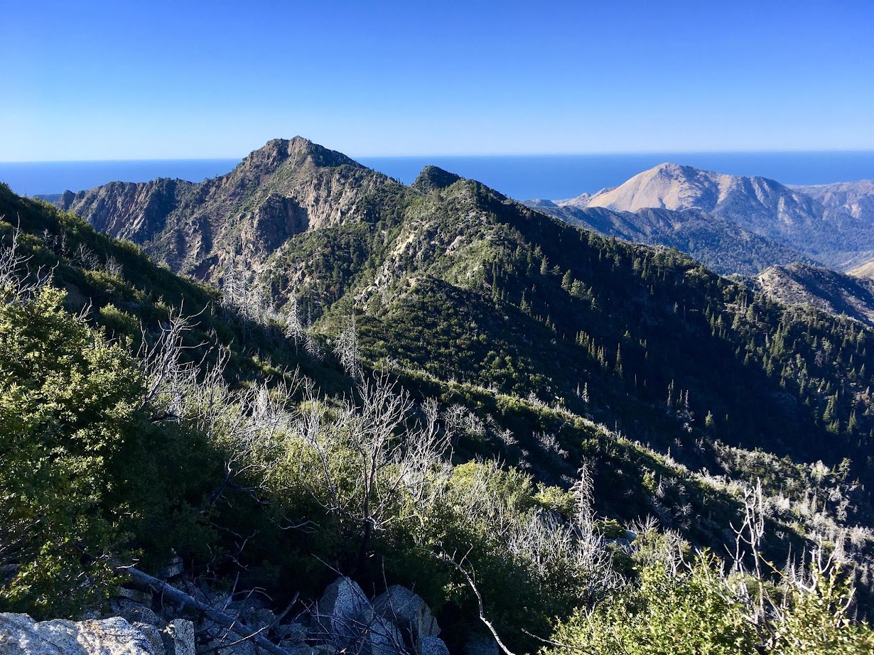
On a clear day, one can look north to Monterey Bay, Santa Cruz, the Santa Cruz Mountains and the Diablo Range. To the south lies the wild and scenic Big Sur River drainage, Coast Ridge, Santa Lucia Peak (aka Junipero Serra Peak or Pimkolam) and Cone Peak. To the east and southeast is Pine Valley, Chews Ridge, Ventana Cone, Pine Ridge, and South Ventana Cone. To the west is the Big Sur Valley, Mount Manuel, Cabezo Prieto, and Post Summit. Immediately below is the immensely rugged and wild cirque that forms the headwaters of Ventana Creek with “the Drain” feature snaking down the canyon. Across this impressive cirque and close at hand is deep and rugged notch known as “The Window” (aka La Ventana) for which the Ventana Wilderness is named. The high point along the ridge to the west is Kandlbinder Peak and Pico Blanco’s unmistakable white apron rises directly above The Widow.


Adding to the allure of Ventana Double Cone is its remote position. The mountain is viewable from the trailhead at Bottcher’s Gap, but it normally requires nearly 15 miles on trail each direction (nearly 30 miles total) to reach. Moreover, there is quite a bit of undulating up and down en route which means lots of elevation gain can be expected in both directions (nearly 9,000 feet in all). In the aftermath of last winter’s storms, the route to Ventana Double Cone has become even longer. With the current closure of Bottchers Gap and the Palo Colorado Road, one has to start farther away with a steep hike up Long Ridge followed by the Turner Creek Trail which meets the Skinner Ridge Trail about a mile beneath Devils Peak. This addition adds over 2 miles to the trip and nearly a thousand feet of steep elevation gain. However, until the Palo Colorado Road is repaid to Bottchers Cap Turner Creek is certainly the quickest route to VDC. The routes from Los Padres Dam, including the Big Pines Trail and Puerto Suello Trail are in poor condition post-Soberanes fire, and while worthy adventures, they will add to an already arduous trip.


While it’s a long way to Ventana Double Cone, the route is immensely scenic the entire distance with views of the Little Sur watershed with Pico Blanco front and center. Largely following the ridge crest that forms the rim of the Little Sur River drainage, the scenery is spectacular and the few remaining forested sections are very pleasant. For most of the route, the effects of the Soberanes Fire are visible everywhere, however the resiliency of nature is also apparent as chaparral is already sprouting up and many new pine saplings are already emerging from ash.


Starting up from the Turner Creek junction to Devils Peak the hillside burned to the ground. From Devils Peak to Pat Springs, there are plenty of gorgeous grassy meadows with spectacular vistas to Pico Blanco, Ventana Double Cone and Kandlbinder Peak. However, this ridge top also served as a bulldozed firebreak. As a result the old tread was largely destroyed and the new tread is uneven and grassy with faint tread due to lack of use. All things considered, however it’s a fairly efficient trip to Pat Springs. Approaching Pat Springs the magnificent ponderosa pine grove was reduced in size once again after the Soberanes Fire, but a magnificent portion of the grove survived right next to Pat Springs.


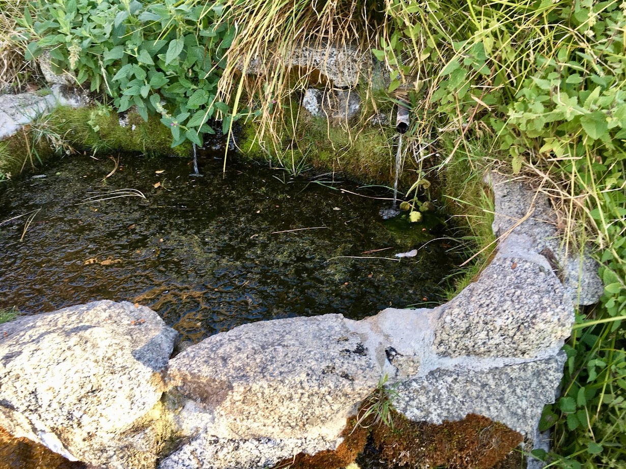
Pat Springs features cool, pure spring waters and it’s a must stop for any traveler continuing beyond to Ventana Double Cone. While there may be water in the springs beyond, none are as easy to access and as reliable as Pat Springs. Unfortunately, the ponderosas just beyond Pat Springs did not fair well and a huge chunk of old trees were burned up to the crown. The next stand of Ponderosas at Little Pines mostly survived but the ground burned severely erasing evidence of trail for the time being. In present conditions it makes sense to bring a GPX of the route available at BigSurTrailMap.net.


Beyond Little Pines the trail traverses beneath Uncle Sam Mountain with several trees down and poor tread. At Puerto Suello Gap the tall chapparal was obliterated and travel on the final portion to VDC begins in a burned section but transitions to unburned. Here the effects of nearly 2 years of no use are plainly visible as immense growth of the chapparal has completely interlocked into the trail in sections. Add in some old snags that have toppled over the chapparal and it’s an arduous finish. The trail stays brushy up until the last 0.5 mile to the summit, which features an awesome Santa Lucia Fir grove.


Another amazing and epic trip report. Your photos make me yearn to hike the area (on a much less aggressive agenda).
I grinned when I saw the rain gauge wondering who has the joy of maintaining it.
Thanks as always.
Hi Leor,
Big fan of your posts, thank you! Question: what brand shirt is the guy in blue wearing with the thumb hole in it? I’ve been looking for a good sturdy work shirt with the thumb holes so I can cover my wrists for additional poison oak protection. Any help would be appreciated.
Thanks again,
Bryan Conant