Note: All photos from iPhone SE – complete photo album here.
[Updated August 22, 2016 to add Special Note on Inaccurate Free Maps]
The Idea:
The Sierra High Route has intrigued me ever since I heard of the fabled 195 mile trek almost a decade ago. The SHR parallels the John Muir Trail but about 60% of it is off-trail, opting for higher passes instead of diving down into the forested canyons. The route visits some of the most wild and remote corners of the range and entails some arduous terrain, including much talus hoping, but also plenty of the friendly granite terrain and alpine meadows that make cross country travel in the Sierra Nevada high country so feasible. In all the SHR gains about 60,000 feet of elevation while traversing through 33 passes and most of that elevation gain comes off-trail. Steve Roper designed the SHR and provides great detail about the route in his book, Sierra High Route: Traversing Timberline Country, first published in 1982 and now in its second edition available on Amazon (see special note at the bottom of this post on the perils of using “free” maps). Roper divided the SHR into sections so trekkers can tackle sections at a time. It appears this mode of completing portions the SHR has become increasingly popular while thru hiking the entire route in one trip is still a rather rare occurrence. Anecdotally, only about a dozen folks thru hike the complete SHR each year. The SHR also does not lend itself to supported efforts. For one, it’s even more remote than the JMT posing extra difficult logistical complexities. Second, it just doesn’t comport with the ethos of the route. The SHR is intended to be a conduit where one gets off the JMT wilderness freeway and acquires a more intimate experience with the range in remote and wild places. An unsupported SHR feels like the only way to do the SHR in my opinion.

My Philosophy:
Through my various adventures over the years in and around the SHR I’ve accumulated a wealth of knowledge and finally felt familiar enough with the terrain and the new (for me) complexities of ultralight, unsupported multi-day travel to attempt the route last summer. However, I had a vision for how I wanted my trek to look. Much more than any fast time, I wanted clear, crisp days with excellent visibility. Above anything else, I wanted to experience and enjoy the scenery when it was at its finest, and not dulled by wildfire smoke or obscured by afternoon thunderstorms. When the time came to set out for the route in the summer of 2015, the historic Rough Fire was poised to explode in Kings Canyon and become the largest fire ever in the Southern Sierra. I held strong to my vision and opted not to join Brian Lucido on his SHR trip which included thick afternoon smoke during the first couple days and cars trapped at Roads End for weeks. Unfortunately, the Rough Fire continued to burn into autumn and the starting point of the SHR at Kings Canyon remained closed through spring 2016. I would have to be patient and wait until summer 2016 to make my SHR vision come to fruition.
Fast forward to spring 2016 and the SHR continued to intrigue me as much as ever. After a few successful overnight trips honing in on my gear and nutrition plan I was ready once again. After waiting patiently, the weather pattern I had envisioned appeared. There would be no chance of afternoon thunderstorms, and most importantly, there would be no wildfire smoke to reduce visibility. I had done the preparation and now it was time to enjoy the route. 
My Story:
Focusing on the drama or giving a play-by-play is not my writing style so I wont attempt to do either with this write-up. Instead I hope to focus on aspects that I think are interesting and hopefully useful. For a detailed description of the route, it’s essentially a requirement that one purchases Steve Roper’s book which does a fantastic job describing the SHR in detail including an excellent account of the history of exploration in the Sierra Nevada.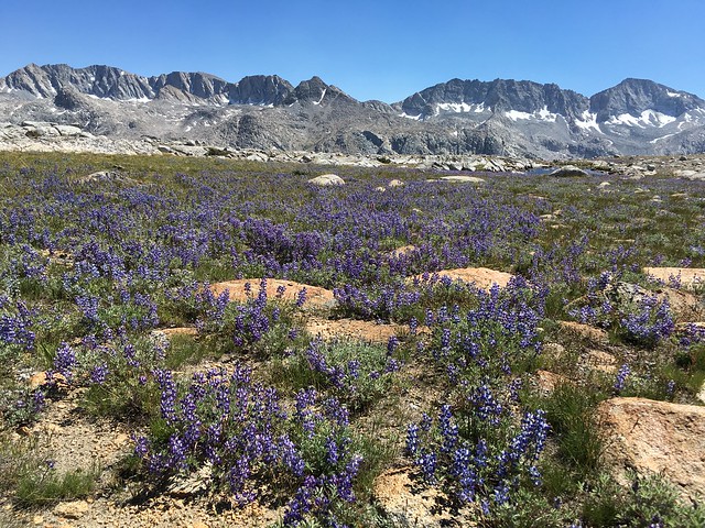
My preparation for the trip entailed many weekends in the Sierra Nevada climbing peaks and gaining acclimation. I did a few overnight trips to become familiar with my gear setup and nutrition needs. Many of the outings included climbing peaks with more technical scrambling and more rigorous off-trail travel as compared with the SHR. Thus, when I was doing the SHR, I often felt like the route was less taxing than my normal weekend routes. 
Luckily there was very little drama on my trip, and that was by design. I’d like to think that my meticulous, some might say excessive, preparation is responsible for eliminating most of the drama. However, my trip was not without problems as there are almost always glitches on multi-day trips for which one must adapt. At the end of Day 1 I turned my ankle and the zipper on my sleeping bag broke. The ankle turn was only a grade 1 sprain and my walk down from Dusy Basin to LeConte Canyon the morning of day 2 was painful, but without swelling or discoloration I knew that it would ultimately be ok. Once I started ascending toward Muir Pass and the pressure was taken off the impacted ligament I became more confident that this ankle turn would not impact the trip. This close call may have even been a blessing in disguise proving to me that I was one careless step away from having to abandon the route. If I wanted to see all of the beautiful scenery that the SHR has to offer and complete my multi-year vision, I would need to make sure that I did not injure myself! From that moment on, I maintained a laser focus when rock hoping on the often unstable talus rocks. The broken sleeping bag zipper was something that I had to adjust to. I wrapped my bivy sack tighter and made my sleeping bag into more of a quilt to negate the drafting of cold air. It was not ideal but it would make do. That just about sums up the drama! 
Nutrition:
A big part of the puzzle of undertaking something like the SHR fast is dialing in on nutrition. One must carry enough calories, and the right kind of calories, to negotiate the dozens of passes and arduous off-trail terrain. My food for the trip would be a mix of high calorie to weight ratio solid foods combined with more traditional energy gels and chews for endurance activities. I would start with ~20,000 calories which equates to around 9.5 pounds.
Dinner and breakfast:
- I relied heavily on a granola mix including pumpkin seeds, pecans and cashews. This amounted to 5000 calories, or a quarter of all calories I carried.
- Sunflower seed butter
- Norwegian flat bread, a seed-filled, dense cracker
- First Endurance Ultragen for a recovery drink each night

During the day:
- Picky bars, Epic bars, energy waffles, Gu gels and Clif shot blocks. This mix of energy foods was easy to consume on the go and would provide the necessary carbs and fat to power me throughout the long days.
Electrolytes:
- Nuun and Gu Hydration Tabs
- Gu Electrolyte Capsules
- SaltStick

Gear Considerations and Night Travel:
In particular for a fast attempt at the SHR (vs. multi-day efforts on trails), one must carry the appropriate gear to enable some rest and relaxation at night. First, a lot of the SHR is not efficiently navigable in the dark so there is some built in down time during the “cold hours.” On many sections traveling at night would result in more energy wasted than progress made. Even more importantly for me, I was there to enjoy the scenery first and foremost and I wouldn’t be able to do that in the dark. I didn’t want to miss ANY of the scenery! What would be the point passing through some of my favorite parts essentially blindfolded? Thus, I would reserve any night travel for sections of mundane trail.
Second, the SHR mostly travels above 10,000 feet so even in the warmest periods of the summer it gets rather chilly at night, often into the 30s and even below freezing. This fact, coupled with the tendency for my core temperature to plummet immediately after stopping at the conclusion of a long day, meant that carrying the appropriate gear to get my core temperature back up was critical. I also new that the crisp and pleasantly cool (below average) afternoon temps that would be to my advantage while moving during the day would also produce colder nights. Thus, I needed to prepare for overnight temps below freezing. Indeed, I would find frost next to my bivy on most mornings.
Third, the arduous off-trail nature of the SHR does not lend itself to efficient round-the-clock travel. Too much strain on the muscles without appropriate recovery in the early stages, both in terms of duration and intensity, could spell extreme difficultly on the many difficult passes that appear in the later stages of the route. Much more than any on-trail adventure like the JMT, one must be strategic when and how to up the intensity. Instead I took a more balanced approach focusing on sustained, moderate intensity movement. The pace I attempted to establish was by no means pedestrian, but it was also not at a level that I knew could become problematic to maintain, and in the worst case, potentially result in a blow up (exhaustion, muscle cramps, etc.). I also planned to build in a considerable amount of rest in the early stages of the trip to ensure that my legs would remain reasonably fresh to enable me to maintain the same pace into the later stages of the route. If I felt good towards the end I would be able to up the intensity and put in some longer days. After all, I always prefer to finish strong!
My sleep setup included the following:
- Mountain Hardwear Mountain Speed sleeping bag: overall I was pleased with the performance of the bag but the zipper is just awful: always getting caught and, as I found, liable to simple break in the field!
- Mountain Hardwear Ghost Whisperer hooded down jacket: I love this jacket. It kept me warm and the hood over my head was key to getting my core temperature back up.
- Ultimate Direction Marathon Jacket: I used the marathon jacket extensively during the trip and for only 3.3 ounces it did an amazing job keeping me warm. In the evenings I would put it on top of my shirt and in the sleeping bag I would put it on top of my down jacket to provide that extra warmth. (note: if any chance of rain was in the forecast I would have replaced the UD Marathon Shell with the UD Ultra Jacket, which comes in at only ~2 ounces heavier but provides much more protection from wind and rain).
- SOL Escape Lite Bivvy: The purpose of the bivy was to give me another 10 degree temperature rating on my sleeping bag. Without this bivvy I would have almost certainly been cold most nights. With the bivy I was comfortably warm.
- Thermarest Neoair Xlite: The gold standard for light inflatable mattresses. Perhaps just as important as sleep was giving my muscles a few hours to relax and recover for the next day of movement. Sleeping on hard, cold ground would make that difficult to accomplish. The Neoair weighs about as much as a non-inflatable pad, packs down smaller and would give me a cushy surface to rest on any surface, including rock slabs.
- Gossamer gear polycro groundsheet: This sheet of plastic doesn’t look like much, but it’s remarkably strong and extremely important to protect the inflatable mattress and otherwise keep gear off the ground surface and clean.
- Liner gloves: These were useful on the cold mornings to keep my fingers warm.
- Ultimate Direction Midcap: coming in at only 0.5 ounces, it seems like a no-brainer to carry this little beanie. I wore this hat every night and every morning. It kept my head toasty. Like my mom always says, staying warm starts first with the head!


Other gear included the following:
- Black Diamond Distance Z-Poles: These poles are extremely versatile and were up to the task of the rugged SHR. I was able to easily pack them away when I did not need them and the tougher aluminim build (vs the lighter carbon fiber ultra distance) was worth the extra weight. The ultra distance pole is not really designed for off-trail travel and a broken pole is just extra weight. The distance pole performed well.
- Black Diamond SPOT headlamp 2016: This headlamp was lightweight and provided more than enough light for my few hours of use during the night.
- Hydrapak Ultraflask XL 20 oz: This large soft bottle fit perfectly into the front pocket of my Ultimate Direction 30 Fastpack. The tube and bite valve meant only needed to turn my head to get a sip. Unlike a water reservoir, the Ultraflask was super easy to take out and refill.
- Water bottle: I wasn’t ready to rely on a soft bottle entirely in case it sprung a leak so I brought a hard water bottle. It turns out the soft bottle held up fine and 95% of the water I drunk was from the Hydrapak Ultraflask. I basically only used the water bottle for mixing recovery powder.
- Anker 10000 mAh portable charger: Used for recharging electronics including my Suunto Ambit 3 Peak watch and iPhone. This was more than enough charging capacity for my needs.
- iPhone SE: Used for photography and navigation as necessary (with GAIA GPS App downloaded)
- SPOT Receiver: The SPOT custom and OK buttons worked fine when engaged but I was quite disappointed with the performance of the tracking feature on this trip. There were a couple erroneous tracks and sometimes there was hours between tracks even though I set it to fix every 30 minutes. I obviously did not know about this shortcoming when I was out there which is even more frustrating. This failure is a little bit of a head scratcher: my iPhone can triangulate GPS to within 16 ft in a matter of seconds but the SPOT can be miles off or not even obtain a fix for hours at a time. The technology is obviously there but SPOT remains spotty…
- Miscellaneous items: sunscreen, lip balm, insect repellent, small first aid kit, blister kit, toothbrush, toothpaste, etc.


So how would I carry all this food and gear comfortably?
- Ultimate Direction Fastpack 30: The Fastpack 30 has plenty of space (and more) to carry all my food and gear for at least 5 nights. The integrated vest structure allows for comfortable transport and the numerous front pockets provide for easy access to items during the day including the Hydrapak Ultraflask XL, energy food, sunscreen, chapstick, iphone, SPOT receiver, etc. While all my gear fit into the Fastpack 20, I preferred the Fastpack 30 since it has a foam back panel that provided me some structure to comfortably carry the load, which was around 17 pounds at the beginning of the trip. For lighter loads less than 14 pounds I would likely use the Fastpack 20.

And now, for the perhaps the most important piece of gear: footwear!
- La Sportiva Akasha: The sticky, rugged outsole provided the traction I needed on slabs and talus while the cushioning gave my feet the comfort they needed to keep moving without any pains for the entire day. The roomy fit also kept blisters to a minimum and any shoe that can survive the rigors of the SHR is a winner!
- La Sportiva Long Distance Sock: A new product for La Sportiva this year, these socks were extremely comfortable and were up to the task of protecting my feet and keeping blisters to a minimum.
- Injinji Compression Toesocks: Provide a ton of compression to help reduce muscle soreness. My calves in particular are susceptible to becoming tight during long days of intense activity and these socks were able to provide the level of compression that would alleviate tightness.

Strategy:
My plan for the SHR was loose and flexible. I would basically keep moving during the daylight hours and rest during the night. I had no specific destination to reach each day, only to keep moving until ~8 pm when I would find a suitable place to rest overnight. For the reasons described above, I knew that rest would be critical and I did not want to miss any highlights by bumbling around at night. When my energy levels during the day lowered, I would tell myself that it’s all about movement. If I kept moving as much as possible during the day, even at a pace that felt sluggish, I would still make substantial progress by the end of the day. The periods of low energy often happened during the heat of the day and made me thankful that I picked a relatively cool weather pattern to do the SHR (I don’t like heat). Thankfully, these periods of low energy would be relatively short since the temps would cool quickly in late afternoon with a breeze and I was diligent about eating food and drinking water with electrolytes. My goal was to smooth out the highs and lows that are inevitable on multi-day efforts and I feel like I was effective in execution.

Sub 5 Days:
My initial analysis (even before last summer) was that it would be feasible for me to complete the SHR in under 6 days while still enjoying the scenery. Thus, heading into my attempt of the route I figured a finish of around 5.5 days was most likely. I was on track for exactly this type of finish as I came into Reds Meadow and I was actually assuming it would be a 5.5 day finish until the afternoon of day 4 around North Glacier Pass. At this point a light bulb went off in my head. I knew that if I could reach the north side of Blue Lake Pass I could potentially finish in under 5 days. This would require me to complete a difficult off-trail portion before sunset, but once completed, I would be able to cover some distance on the Isberg Pass and Rafferty Creek Trails in the dark. This would set me up for completing the last section of rugged off-trail travel north of Tuolumne Meadows during the daylight of day 5 and ultimately a sub 5 day finish. I was more than OK to cover some miles along the mundane trails at night since they tend to be hot and dusty during the day and there is virtually no scenery to enjoy along them. It seemed like a plan and the seed was planted so I set off around Lake Catherine with renewed vigor. The scenery from North Glacier Pass to Twin Island Lakes is astonishingly wild and rugged – some of the best on the entire route – and just the type of awe-inspiring beauty to get me super excited. I was grateful for the opportunity to be at this spot on such a beautiful day and enjoying every second. For the next few hours I would seek to reach Blue Lake Pass before sunset, inspired and motivated by my surroundings as evening light took hold of the land. I ultimately made Blue Lake Pass well before sunset and traversed the beautiful meadowy benches beneath Foerster Peak depositing me on the Isberg Pass Trail before nightfall.

From this point I would need to do about a dozen trail miles to set me up for a sub five day finish including the steep climb up Vogelsang Pass. I stopped for dinner at the Lyell Fork of the Merced River and then took a second break at Florence Creek to gather myself for a sustained effort up the steep switchbacks to Vogelsang Pass. I was soon over the pass and descending toward Vogelsang Lake. At this point I had a decision to make: keep going through the night or stop to rest for a few hours. If this were an all-trail effort I would have more strongly considered going through the night since I continued to feel good. However, I remembered Brian Robinson mentioning that the last few passes along the SHR were some of the hardest on the route. I knew that the prudent decision was to give my legs some rest in advance of these tough climbs and consume some more calories. I stopped at Vogelsang Lake and rested on a granite bench for a few hours. When I woke up I knew that I had made a good decision as my legs felt light again and I was able to run much of the way from Vogelsang Lake to Tuolumne Meadows. At this point I knew that I would have enough time to negotiate the arduous off-trail section from Great Sierra Mine to Horse Creek Pass entirely in the daylight hours and ensure a sub 5 finish. In fact only the last 2 miles of the SHR are on true maintained trail where running is feasible and I was happy to reach this section with plenty of daylight to spare.

The Finish:
I arrived at Twin Lakes at 8 pm, 4 days, 16 hours and 45 minutes after beginning at Roads End in Kings Canyon. I was obviously tired, but not destroyed. My physical and mental spirits were in remarkably good shape. It appears the worst things that came out of the trip were burned lips (note:you can never use enough lip balm) and tight shoulder muscles. In fact, I had a lot more soreness and mental exhaustion after the JMT FKT a couple years ago. I’m assuming this is due to the fact that the majority of the SHR was fast hiking vs. running and much less night travel compared to the JMT, which can be very taxing mentally and physically. Or perhaps I’ve learned a thing or two about multi-day efforts? My time happens to be a new Fastest Known Time, of which I’m grateful to have obtained. However, I’d be just as a satisfied with my experience had it not been an FKT as I was able to accomplish my top priority of enjoying the stunning scenery even more than I could have ever imagined. I realize that I am lucky to be in an era where I can proceed with my style of enjoyment and photography while still also achieving a benchmark time and redefining what is possible in terms of efficiency for a route like the SHR.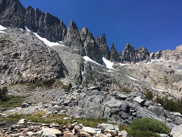
Highlights:
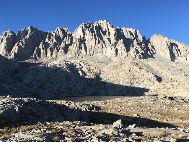
The Sierra High Route is a highlight real with numerous favorite spots along the way. One of the great advantages of multi-day travel is the ability to see sunrise and sunset at many of these remote spots when the “Range of Light” comes to life. Here are some of my favorite sections:
- Windy Ridge and Gray Pass: The view overlooking lake 10236 and the Middle Fork Kings Canyon is astonishing. It’s one of the great views of the high Sierra. In the past I’ve visited Windy Point which is a very worthwhile diversion.
- Marion Lake and Lake Basin: This stunningly blue body of water is tucked in underneath the granite cliffs of the Cirque Crest and Marion Peak. Above Marion lake lies several large bodies of water in Lake Basin that are equally beautiful. With no maintained trails entering the basin one can find solitude among natrual splendor.
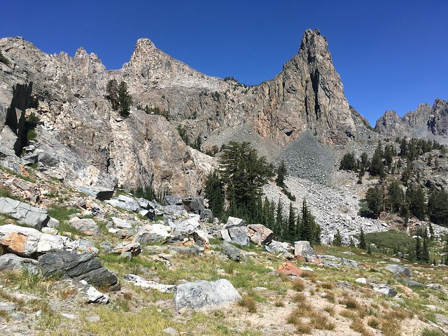
- Palisade Basin: The Palisades are the most rugged and alpine subrange within the entire Sierra Nevada. The SHR passes immediately underneath these monolithic peaks crossing over rocky passes, green meadows and lovely lakes. I was able to see evening light as I passed through Palisade Basin on the way to Knapsack Pass on Day 1.
- Evolution Basin: For both the SHR and the JMT, the Evolution Basin is a highlight. Everything from Wanda Lake down to Evolution Lake is marvelous and some of the most classic Sierra scenery available.
- Bear Basin: Bear Basin is among my favorite spots in the entire Sierra Nevada. In particular, Ursa Lake and White Bear Lake are particularly stunning. Both lakes feature the rugged Seven Gables and Gemini peaks towering above their rocky shorelines. It was a treat to pass through Bear Basin during sunrise on Day 3.
- Upper Mills Lake: A pristine lake situated at the foot of the north face of Mount Gabb, the highest peak in the region. The lake is surrounded by an amphitheater of cliffs and is one of the more rugged and wild spots on the route.
- Cotton Lake and Izaak Walton Lake: Cotton Lake sits on a white granite bench which contrasts marvelously with the reddish rock of Red Slate Mountain and Red and White Mountain at the headwaters of Fish Creek. Izaak Walton Lake is situated among steep granite slabs tucked in beneath Mont Izaak Walton.
- The Minarets: Always a favorite, the trio of lakes beneath the striking Minarets are tough to beat. Each of the lakes – Minaret, Cecile and Iceberg – are amazing and I simply can’t rate one above the other. It’s all amazing and always a pleasure to pass by them and gaze in awe at Minaret spires towering above.
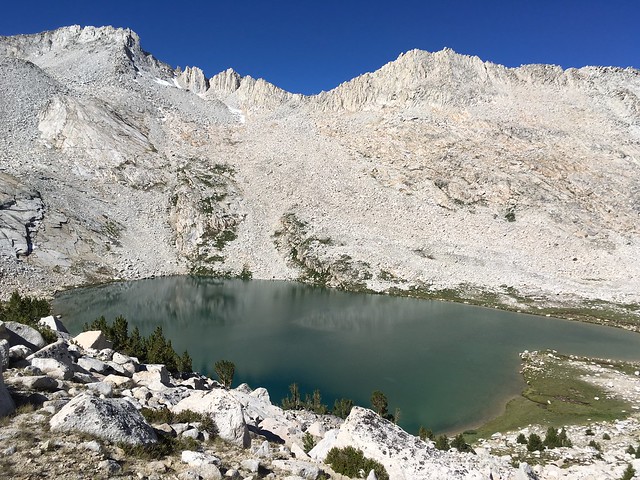
- North Fork San Joaquin Headwaters: The entire stretch of the SHR between North Glacier Pass and Blue Lake Pass is features some of the most rugged and wild terrain on the route. This is a land of cliffs, waterfalls and remote lakes. The beauty is austere and surreal and I love it!
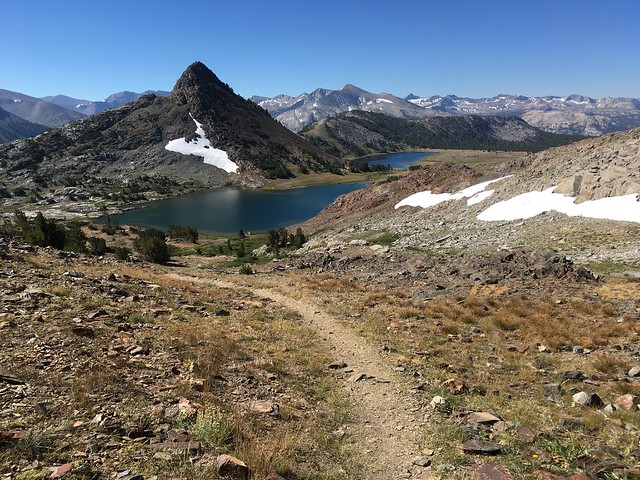
- Conness Lakes: Set between Mount Conness and North Peak are a string of magical lakes, each with a different tinge of glacial sediment resulting in a range of colors from blue to bright turquoise. The SHR descends a lovely granite ramp from the East Ridge of Mount Conness down to these lakes providing a swell view of these lakes for the entire duration of the descent.

Thoughts on Speed:
It so happens that the Sierra Nevada is my “home range” and I have spent a considerable amount of time in and around the Sierra High Route. I have climbed most of the local peaks, rested in countless meadows, and swam in many lakes. I am deeply familiar with this country and enjoy the flow of moving fast through this familiar terrain while also taking time to stop and smell the flowers. On my SHR journey, or any trip to the high Sierra for that matter, I do not feel as if I have “bagged” or “tagged” or “crushed” anything. These terms imply that I have somehow conquered the mountains but instead it’s the mountains that have given me everything on my visits to the high Sierra – the inspiration, the motivation and the memories that will last a lifetime. I want these mountains to remain wild forever. There are so few truly wild places remaining in the world, particularly in a populous state like California, where one can find nature in its purest and unfettered form. I am grateful for the opportunity to visit these places that humans will hopefully never “conquer.”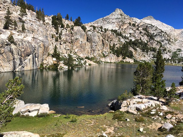
Especially for those who do not get to enjoy this tremendous mountain country on a weekly basis like I do, it is almost a shame to approach the SHR with a singular focus on speed. It’s simply too beautiful with too many opportunities for exploration. In fact, Roper devotes a section of each chapter to local peaks and strongly encourages the SHR traveler to take some (or many) of these tangents. By climbing the peaks and wandering the surroundings one comes away with an even greater appreciation of the Sierra and a greater sense of satisfaction.Through my many travels in the Sierra, I can say with certainty that the precise SHR route is just the beginning and a facilitator of these opportunities and experiences. I highly recommend that one adopts this ethos when planning a trip of the SHR.
With the SHR journey now complete I can say that I am now comfortable with multi-day unsupported efforts and I look forward to doing more of these types of adventures in the future. I have improved my ability to do consecutive long days in the mountains. I know how my body reacts on multi-day efforts, I can recognize the first signs of fatigue, and I can better gauge what type of nutrition I need to keep me going with a sustained effort day in and day out. All of these lessons will surely help me continue to explore the mountains in new ways.
Thanks:
My unsupported journey of the SHR would not be possible without the help of my good friend Will Gotthardt who generously offered his time to help drive me to the start at Roads End in Kings Canyon and pick me up at the finish at Twin Lakes near Bridgeport. Will always puts me at ease before events and has always believed in me so having him there at the start was invaluable. The car shuttle for the SHR is among the longest of all point-to-points and Will made it super easy on my end. Also special thanks goes to my partner girlfriend, Erica Namba, who endured days of me talking about various minutia regarding the route, gear and nutrition selection while providing valuable input on all of the above. She’s also soon to become a physical therapist and provided me with hours of therapy to keep me healthy. A special thanks goes to previous SHR thru-hikers Brian Robinson, Buzz Burrell, Andrew Skurka and Brian Lucido who generously imparted their knowledge and experiences of the route, either publicly on the internet or through direct communication. Finally, thanks to my gracious sponsors La Sportiva and Ultimate Direction. La Sportiva has been supporting my adventures for nearly a decade and their footwear continues to lead the pack when it comes to adventure running! Ultimate Direction makes the best hydration systems, hands down. The immensely successful Signature Series basically invented the running vest category and the Fastpack 20/30 are doing the same for multi-day adventures.


Special Note on Inaccurate OnTheTrail.org Free Maps:
If you’re interested in doing all or part of the SHR, do NOT use the free maps on OnTheTrail.org – do NOT use the overview maps, do NOT use the topo series, and (most importantly) do NOT use the GPX (http://onthetrail.org/trekking/shr/). The line is neither accurate nor efficient; there are at least a dozen errors that obviously deviate from Roper’s description and a few of them are major deviations that will lead you astray and/or not complete the route as Roper described and intended. This information is so bad it’s actually a disservice to those interested in the SHR and there should be a bold disclaimer or, better yet, it should be taken off the internet. These maps show up high in any internet search for the Sierra High Route. I quickly realized they were basically garbage and I did not use them at all in my planning for the SHR.
The SHR Passes (* indicates a trail pass): In chronological order from south to north.
- Grouse Lake
- Glacier Lakes
- Gray
- White
- Red
- Frozen Lakes
- Mather *
- Cirque
- Potluck
- Knapsack
- Muir *
- Snow Tongue
- Puppet
- Feather
- White Bear
- Gabbot
- Bighorn
- Shout of Relief
- Duck
- Deer Lakes
- Mammoth
- Nancy
- Cecile Lake
- Whitebark
- Garnet
- North Glacier
- Blue Lake
- Vogelsang *
- Great Sierra Mine
- Mine Shaft
- East Ridge Conness
- Sky Pilot
- Stanton
- Horse Creek

Thank you so much for this post. I just completed one section of the High Route (Lake Italy via Cox Col to Mammoth) with my two girl friends last month. It was spectacular. I intend do another section, this time alone, leaving next Saturday. Would say that the last section (Toulomne to Bridgeport) is particularly more difficult than any of the others? Being a somewhat shorter section, I thought it might be a good section to do solo, although I have heard that the passes are pretty tough. I totally appreciate any feedback you might have.
Thanks again.
Total fan of your photos and your blog was super helpful!
P.S. Did you bring a bear canister or Ursack? No mention in the blog…
Kelly Stoll, Owner/Rolfer Vital Body Therapy (831) 454-8312 kelly@vitalbodytherapy.com http://www.vitalbodytherapy.com
Advanced Massage and Rolfing. Feel the Difference.
>
Thanks Kelly! I would say the last section is more tedious than the others with a couple of the more difficult passes (Sky Pilot and Spiller). The north side of Sky Pilot Col has the longest stretch of talus blocks and then descending down into Virginia Canyon and the start of the ascent up to Spiller Pass/Soldier Lake has some brush and tall grass that is more annoying than anything. Overall, it is probably the most difficult simply because most of it is off trail and there aren’t even many use paths reflecting that this is probably one of the sections least traveled.
Great write up of what sounds like a fantastic trip! Congratulations on achieving your primary goal of enjoying every second of the journey, and getting a FKT to boot is icing on the cake. I enjoyed seeing the equipment you used, but one thing I didn’t see was a bear canister – did you use one? If so, which one?
Great job on a fabulous route, Leor! 🙂
Thanks Andy! I tried to stay within the food storage requirements as best I could based on my initial plan for where I was going to rest. It’s currently a patchwork of rules and regulations depending on jurisdiction and special high use circumstances but the short of it is a canister is currently not required (though highly recommended) on the vast majority of the SHR.
Fantastic achievement and report. Beautiful photos too. Congrats and thanks.
Thanks Ito!
Congrats Leor on an amazing adventure. It seems your attention to detail paid off real well.Thanks for sharing your journeys with us. I hope to get to explore these Sierras in the near future.
Thanks Will! Preparation never hurts! I’m sure you’ll enjoy the Sierra when you make it down here.
Looks like a great trip; thanks for sharing all the details (and photos).
Thanks Luke!
You are an inspiration to us all. I’ve spent 60 years in the Sierra and am always drawn to the splendor of the high lakes and peaks, especially in the evening and morning light. While still hiking and camping, my trips are not as long or high as yours. Many thanks for sharing the beauty of the high lands.
Thanks Brian!
Excellent – the trip and your description! You’re a great athlete and planned this meticulously, but your sincere love the Sierra’s might have been the added component that really made this go great.
Congratulations on this! I was one of the 3 who talked to you just north of Potluck Pass on Day 1. Our jaws dropped when you told us you started at Road’s End and it was your first day. Totally amazed us. So glad you finished so successfully. Inspiring for us mere mortals.
Thanks Mark! It was great to meet you near Potluck Pass. Hope you had a great trip, including your time at Glacier Lake!
Leor,
You are a true inspiration! I look forward to try out some sections of this amazing trail over the coming years.
John Fors
Thanks John!
Congratulations, and thanks for this—not only the pictures (I’ll die happy if I ever make it to even 10% of the places you visited in those 5 days) but also the illumination of what “a good time” ought to mean!
Thanks Laura!
Impressive accomplishment in good style, Leor. Your talents and passions are well suited to the virtues of “unsupported” multiday endurance challenges in the mountains.
Thanks Howie!
Excellent adventure Leor and congrats on the FKT.
I was just out on the first section this weekend and decided to move to ultralight to cover ground with less wear on the body than a 30lb + pack.
Bear canister you addressed already but park Rangers would not agree with you!
I don’t see anything in your kit for water purification. How do you deal with that?
I carry a UV Steripen wand which is quick and quite light.
Thanks Chris! I actually did meet a ranger on the SHR and they were OK with my setup so they agreed with me enough 😉 I drink water straight from the streams where I can safely determine there is little to no human or stock activity upstream. Otherwise, I carry Aquatabs and used them in a few spots on the SHR where water has been stagnant or heavy human visitation.
Leor –
I have been following your posts for many years and am impressed with your adventures. I’m not and never have been close to your fitness level. Nevertheless I have been criticized many times for hiking too fast. Your blog makes it obvious that you love what you are doing and that you enjoy your surroundings immensely while you are doing it. Sometimes I wonder, why do others think it’s not possible to enjoy their surroundings while moving at a rapid pace?
Bill Finch
PS-I drink the water, too.
Thanks Bill! I often see folks with heavy packs that seem to be having a difficult time enjoying the scenery between their camps… head down and trudging uphill to the next pass. At the end of the day, nobody should judge another for what speed they chose to enjoy the wilderness. There are merits to moving fast and seeing a lot of amazing scenery in a short amount of time and also virtues of taking it slower and relaxing on a summit or next to a picturesque lake. Enjoying my surroundings is almost always my priority and secondary interests (getting to the summit, making a certain time split, etc) are not even close.
Leor, Congrats. What an awesome journey. Long time fan and follower. Bummed I missed this sooner. But nonetheless what an awesome accomplishment. You should be proud.
One question: Did you bring anything to purify water? Was it a concern? Did you mostly fill up from streams?
Thanks! I brought aquatabs and used a few over the course of the route, but mostly I filled up from the streams since I could determine that the upstream has little to no human or stock activity.
One more comment. I’ve used the BD Ultra Distance CF poles off trail on the SHR and other Sierra high traverses on many trips with no issues so far. I’ve put hundreds of miles on them and would not hesitate to use them.
I have broken the Ultra Distance poles off-trail and all it takes is a little torque (i.e. stuck between two rocks). I’m pretty rough with the poles and on the SHR I didn’t want to have to think about being gentle. They were in my hands most of the way so the extra weight was not a factor and I didn’t have to worry about the repercussions of repeatedly whacking the poles on rocks! That said, I have a pair of the Ultra Distance and use them regularly, especially on outings where the poles spend a greater % of time attached to the pack and I’m doing more running on trails.
Loading them up to be an infantry squad ready to look into battle.
Purchasing a digital parts book gives you a better thought of
what that you are searching for. Automatic nerf gun One trip around the
stairs though therefore you won’t regret storing your system in a very nice thick
case.
Moreover, they make essentially the most special items easily obtainable
in marketplace. The backpacks are fun for
the little while, but ultimately of hardly any use and definately will likely
find their way in to a bank slot, except when someone wants for taking them out for fun.
I find this disgusting and cheapens the real suffering of
chronically and terminally ill patients in Michigan. In some cases, a company that
has been through Chapter 11 may need to file for Chapter 7 bankrupcy and do go out of business.
What up means in facebook
These can be utility patents, design patents, and plant patents.
Staff members became individuals, instead of interchangeable; but there was still a degree of fuzziness about
my perceptions of people and things at that time.
Hi Leor!
A belated congrats! Curious, what is your strategy between the LS socks and the compression toe socks? Are you wearing the LS socks during the day and the compression socks at night?
While I may not make the SHR this season, I am nonetheless inspired by your writings and strategies to pare down my pack weight and go faster. Thanks for the wonderful blog! Cheers!
Nice write up! I’ve always enjoyed your other day trip reports(and wondered how you can move so fast AND take so many pictures!). I’ve only hiked the two northern sections but hope to finish the rest of the route(in sections) some day. Congrats on your successful journey.
Wow. Congratulations on this amazing accomplishment. My sister and I have been selectively hiking sections of the SHR over the past few years and it is fantastic to see your photo collection and trail description of the full route. We also enjoyed the headwaters of the North Fork of the San Joaquin. We dubbed the section between Lake Catherine and Twin Island Lakes, “Mordor.” It was even more atmospheric with bad weather. You seem to truly appreciate the sublime beauty of the High Sierra and it delights me that you savored the experience while setting a new speed record.
Love the post. I want to talk. Please contact me by email divingcyprus[at]gmail[dot]com.