The La Ventana Loop is a tremendous route that was as difficult as it was beautiful. To my knowledge Kandlbinder, La Ventana (aka The Window), and Ventana Double Cone have never been climbed together as a day trip. It took Brian Robinson, Whit Rambach, Joey Cassidy and me a little over 13 hours to complete the loop (start at 6:40 a.m. and finish at 7:50 p.m.). The route had a little bit of everything: spectacular scenery (including coastal Big Sur and interior Ventana), remoteness, ruggedness, hideous brush, stream crossings by the dozen, waterfalls, old growth redwood groves, old growth Santa Lucia Firs, exposure, commitment, rock scrambling, treacherously loose rock, and a beautiful sunset. In all, the La Ventana Loop is around 30 miles with 9,500 ft of elevation gain, but the stats belie the difficulty of the 3 mile traverse between Kandlbinder and Ventana Double Cone. Garmin Connect Data: http://connect.garmin.com/activity/430728534
Back in December on the Ventana Double Cone trip, I was captivated as I gazed across the immensely rugged cirque to La Ventana and Kandlbinder and hoped to one day stand on those points. I recalled hearing about a route up Jackson Creek that provided direct access to La Ventana and wondered if a giant loop could be made that would include the summits of Kandlbinder and Ventana Double, essentially encircling the Little Sur drainage. In order to make the loop a reality, one must traverse between La Ventana and Ventana Double Cone, a stretch that has virtually no recent information and looked like brush hell on satellite. For a couple weeks I focused more on ascending Kandlbinder as an out-and-back via the Jackson Creek Route which has some recent route beta, but discussion with Joey reignited my interest in tackling the La Ventana Loop sooner rather than later. In a matter of days I was ready to tackle the challenge after discussion and careful satellite analysis. With a great weather forecast, the team of four was assembled at Bottcher’s Gap in the pre-dawn hours and pumped to give the La Ventana adventure a go.
Click for a full-size annotated view from Kandlbinder Peak

There is little information on this wild and rugged area of the Ventana Wilderness and virtually no information about the traverse between La Ventana and Ventana Double Cone. It’s a committing route that is extremely arduous, requiring advanced navigational skills and wherewithal to persevere through extremely difficult terrain and hideous brush. That being said, here are my thoughts on the segments of the La Ventana Loop:
- The Little Sur River: After a 3.5 mile run down the dirt road to the Pico Blanco Boy Scout Camp from Bottcher’s Gap, we took the Jackson Camp Trail to Jackson Camp. This trail is in good condition and a pleasant run through lush redwoods. Beyond Jackson Camp there are numerous crossings of the Little Sur River and we walked right through the water in the interest of time (although rock-hopping is possible in low flow). The use path is fairly easy to follow between crossings and most of the crossings are flagged. 1.3 miles from Jackson Camp is Fox Usecamp, a nice flat spot amid redwoods where Jackson Creek flows into the Little Sur River. At Fox Usecamp, we turned up Jackson Creek and soon came across a pretty waterfall known as Firehose falls.
- Jackson Creek: The Jackson Creek route proved highly enjoyable. The old growth redwoods in the canyon were amazing and the stream was pretty with small cascades and pools. By taking the path of least resistance we were able to make decent progress. There are lots of down trees to go under, over and across. Beyond Happy Fork Camp, we traversed a little above the stream before heading up grassy slopes in oak woodland to a small saddle above Jackson Creek. A quick descent from the saddle brought us to a dry streambed that drains the slopes of La Ventana and Kandlbinder in periods of heavy rain. This area had plentiful poison oak but travel through the brush was reasonable.
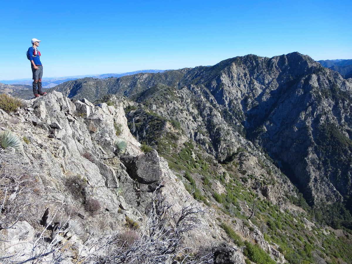
- Kandlbinder Direct: We took a talus gully up ~1,400 feet from the bottom of the canyon below La Ventana directly to the summit of Kandlbinder. The climbing was sustained and sometimes loose, but brush-free. This is a phenomenal route amid old growth Santa Lucia Firs and the view from Kandlbinder is amazing, perhaps the best in all of the Ventana Wilderness. We arrived at Kandlbinder in under 5 hours from Bottchers Gap. This turned out to be the easy part.
- Kandlbinder to La Ventana: From Kandlbinder, we stayed below the ridge crest to avoid copious deadfall from the Basin Complex fire immediately on top of the ridge. While the terrain is mostly brush-free, it is very steep with cliff bands and the rock is treacherously loose requiring care and extreme caution.
- La Ventana: We traversed around some cliffs and ascended the final slopes (much poison oak) to the famous notch known as La Ventana (aka the Window) for which the Ventana Wilderness is named. La Ventana is a fascinating spot, although it’s largely filled with brush these days.
- The Impasse: The cliffs on the east side of the La Ventana notch are a formidable obstacle to continuing the traverse to VDC. Such an impasse is something I would expect in the High Sierra, not the Santa Lucias. We couldn’t find any safe ledges (without technical gear) in the vicinity of the notch and descended several hundred feet where we found a safe passage with some class 3 moves.
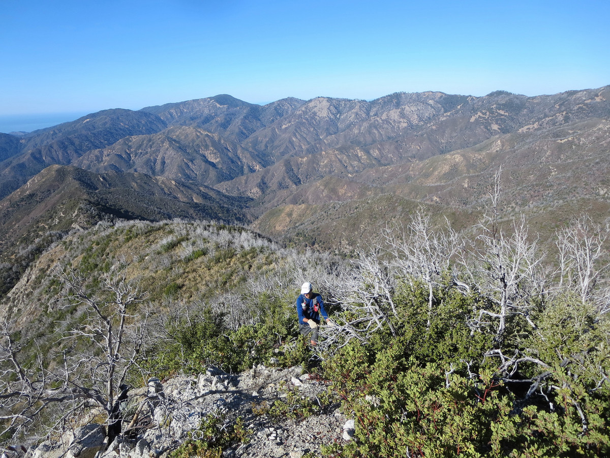
- The Crux: Once we got through the cliff band, we encountered fairly thick brush as we made an ascending traverse back to the ridge crest. From here to the next high point on the ridge had truly hideous, atrocious brush. The dead manzanita and other spiny vegetation combined with the flourishing new brush growth made travel extremely arduous and slow. The brush was worst right on the ridge crest where deadfall was abundant. After careful investigation of satellite imagery before and after the trip, I’ve concluded that this section is a slog no matter which way you cut it.
- The Ridge Traverse: From an intermediate high point along the ridge, the next section was rocky with little brush and we made good progress for awhile and enjoyed the exposure on both sides of the ridge. However, we soon encountered another wall of brush and deadfall. We descended off the ridge a couple hundred feet down extremely steep and loose slopes to traverse around this brush. We ascended back to the ridge via another talus gully that was brush-free. Now back on the ridge, we enjoyed another nice rocky section with amazing views into Ventana Creek and VDC. After this point we made a direct line across the basin to the Ventana Double Cone trail. The brush in this final portion is much more manageable.
- Ventana Double Cone: Elated to be back on the trail, we ran up to the top of VDC and enjoyed the late afternoon views from this awesome summit. In all, it took over 3.5 hours to complete the traverse from Kandlbinder to La Ventana to VDC.
- Completing the Loop: From VDC we took the trail back to Pat Springs and Bottchers Gap. We had a spectacular sunset from Little Pines overlooking Pico Blanco and drank up the cool, fresh waters in Pat Springs. A full moon and warm evening temps made the last 7 miles from Pat Springs a pleasant night run. The trail is getting some more work and is in decent shape, or maybe it just felt like a highway compared to the brush we endured on the traverse.


Note: The following photos are in chronological order from the Little Sur River at daybreak to the group shot at Bottcher’s Gap after finishing in the dark.


Nice trip 😉 Did you use the ultra trace mode on your Fénix?
Regards 🙂
Nice Loop ! We did the traverse from VDC, over kandlbinder and to the coast via Mt Manual. That was the 2nd day of our 2-day backpack. I think the dense brush is what makes it memorable.
https://plus.google.com/photos/117142671956042478581/albums/5539953858502496321/5539954623753885490?banner=pwa&pid=5539954623753885490&oid=117142671956042478581
Here is some additional information on the “route” (definitely not a trail!) across the Ventana Ridge from Pine Ridge Camp to the Double Cone, thence to the Window, continuing along the ridge over Kandlbinder Peak, past Muhlberger Dome (unofficial names), dropping down into the South Fork of the Little Sur to Tin House, and then picking up the trail past Vado and Pico Blanco camps out to the old county road. Exits to PBBSC or Big Sur are possible alternatives.
In the early to mid-60s Ward Allison and a group of hardy hikers started work on this route, which generally followed the 4000′ contour across the Ventana Ridge, staying within a few feet (c. 15′) of the top. The hardest part was the thick chaparral just west of Pine Ridge Camp, and only a minimal amount was removed. In c. 1969, a group of 8 of us (my husband Graham, our two children Kim and Weegie [then c. 11 and 9], myself, our two Labrador dogs (mother and daughter, and Marcel Setletzky and his son [then c. 8], made this trip in about five days, counting the first day in from China Camp to Pine Ridge. Ward had told us that we would find several gallons of water at “Gunnel’s Rest” (Marcel’s wife at the time); but when we arrived there the Clorox type bottles had been destroyed by the elements. Graham and Marcel then made the tough descent some hundreds of feet till they could replenish our water supply from the very headwaters of the Big Sur. As I recall it was one of the few places where a group could actually camp on the ridge top.The next day we continued on over the South Ventana Cone; it was very slow going, as we were doing minor improvement along the way, but the route was obvious. We camped at the Double Cone the third night and then made the fairly steep traverse and descent down to the Window, using a rope for a short stretch to secure the kids and dogs, continuing on to the Little Sur and out the next day. As far as I know, we were the only party ever to do the complete route, at least among members of Ward’s apocryphal “Los Padres Hiking Club.”
It was certainly never intended for that route to be considered a “trail.” It was simply one of the 10 routes to The Window designed by Ward Allison and fellow conspirators that appeared in the June 1968 issue of The Ventana, newsletter of the Ventana Chapter of the Sierra Club. It’s possible that the idea of a real trail was picked up by others who saw the map and accompanying story about a famous “camp-in” at the Window on May 25, 1968, humorously described by the aforementioned Marcel Sedletzky. I recently gave a copy of that map to Jack Glendenning for his recent trip to The Window. If people are interested, I’m sure he could post it to the VWA site. However, it would doubtless be extremely difficult to follow after the various fires and resurgence of the chaparral!
Cheers, Corky
Corky,
I know you had an intrepid youth, as evidenced in your story above. I am glad you are still attuned to the ridges and valleys of Big Sur. I am having to work hard to catch up. I was at the Window and Kandlbinder earlier this week (5-2-2016). It was grueling, to say the least, but extremely beautiful. I had my lab, Bob, along, and he is not speaking to me now. Camped at Happy Fork, looped through the Window, Kandlbinder and then down a ridge and traversed to Jackson Creek on a route that required a lot of low-crawling and muttering.
Regards,
Don Gruber
Wow! I just finished a backpacking trip to Ventana Double Cone out and back via bottchers gap and can’t imagine doing this in one day. Very impressive!
I’m considering backpacking this loop over Memorial Day weekend. Do you have any tips to avoid getting lost? It appears that a couple sections on this loop aren’t really “official trails”. Thanks!
Leor,
Thanks for your meticulous, detailed account. I read this before attempting the Window/Kandlbinder, and it was helpful, especially the annotated photos. Still, that did not stop me from getting lost and battered. My first attempt was from the VDC, in November, and threat of darkness stopped us (1 partner and 1 chocolate lab) short of the Window. Despite that we did not make it back to Double Cone Ridge until well after dark.
This week, May 2, 2016 we, the same team, came at it from the Scout Camp through Jackson Creek, camping at Happy Fork. The hike to the Window was hard work, but manageable. The traverse to Kandlbinder was much more difficult. We descended from Kandlbinder on the ridgeline that becomes the western side of Jackson Creek, and midway down that traversed in totally unknown territory to try to make it back to the Divide below the Window, and a known trail. However, it quickly got dark and the return route was difficult to find by headlamp.
Your pictures of your recent ascent to Kandlbinder show a large, open talus slope, with very little brush. I couldn’t locate that; it would have been better than the ad lib route we followed.
I saw your name a couple of times in the Window Walker’s Log, and in the Kandlbinder log as well.
Thanks again for the useful info.
Regards,
Don Gruber, Del Rey Oaks