
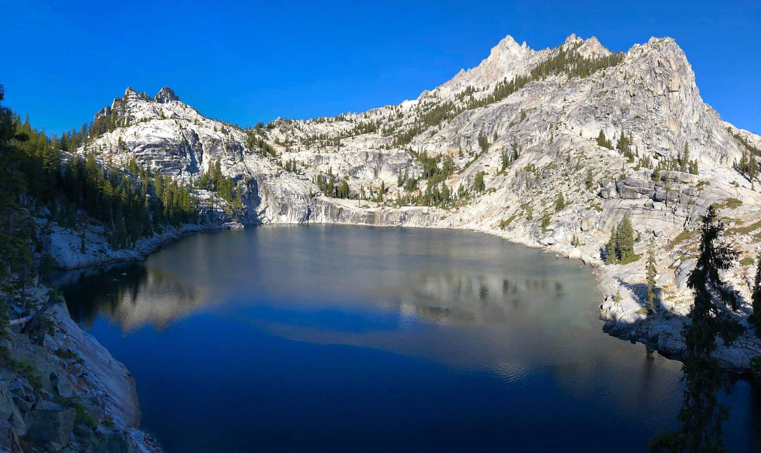
Sawtooth Mountain is positioned in the heart of the Trinity Alps. As the name would suggest, the mountain is rugged from all directions and is almost entirely composed of the glacier-polished white granite that is characteristic of the region. While not the highest peak in the Trinity Alps (~100 feet short), Sawtooth Mountain is arguably the quintessential peak of the Trinities. Its profile is instantly recognizable from surrounding peaks and the summit is remote and challenging to reach from any direction. Sawtooth Mountain’s centralized location affords a tremendous view of the rugged Trinity Alps. At the foot of the peak lies one of the great gems of the Trinities in Smith Lake, its clear and deep waters completely surrounded by polished granite slabs. Arguably the most scenic route to reach Sawtooth Mountain begins in the lush temperate forest along the Stuart Fork of the Trinity River at around 2,600 ft and a dozen miles later reaches the rocky summit at around 8,890 ft. Along the way the route passes by the lovely Alpine Lake and ascends to the granite wonderland that holds Smith Lake and Morris Lake, perhaps more of a highlight than the summit itself. In all, it’s around 24 miles roundtrip and over 10,000 feet of cumulative gain via this route which is described below. A slightly shorter route with less cumulative gain is via Canyon Creek Lakes and “L” Lake, but as is usually the case, it’s about the journey and not the end point. Full album here taken from a trip in November 2018.


Beginning at the Stuart Fork Trailhead, take the well-used and maintained Stuart Fork trail. The first 5 miles include several ascents and descents to cut across bends in the river so it is not nearly as flat as one might imagine for a trail that largely follows a gradually ascending river upstream. At 5 miles reach a junction and turn left to head down to a bridge-less crossing of the Stuart Fork Trinity River. As this river drains a large portion of the Trinity Alps it is often completely impassable during the snowmelt season. This crossing may even prove difficult into mid summer in a high snowfall year. By late summer and into the fall most of the snow has melted and the river recedes to the point that this crossing becomes a rock hop. As always with swift river crossings, assume that the depth and force of the water is stronger than it looks! Find the trail on the other side of the river crossing and head left (south) and the trail commences a steady ascent into and up the Boulder Creek drainage. At about 6.5 miles from the Stuart Fork Trailhead reach another junction. To the right the Boulder Creek Trail heads over a pass and into the Canyon Creek drainage. To the left the trail heads up for Alpine Lake. Take the left fork and soon the rate of ascent increases as the trail switchbacks up the increasingly steep hillside. Pass through lovely black oak groves and then emerge into the alpine environment characteristic of the Trinity Alps. The upper portion of the trail becomes more technical with many rocks in the trail. At about 8.5 miles reach the flat meadowy area just before the pretty Alpine Lake. Alpine Lake is nestled between cliffs that form Little Granite Peak to the south and unnamed summits to the north. A nice grove of Brewer’s weeping spruce occupies the lake basin with some impressively tall and large specimens.


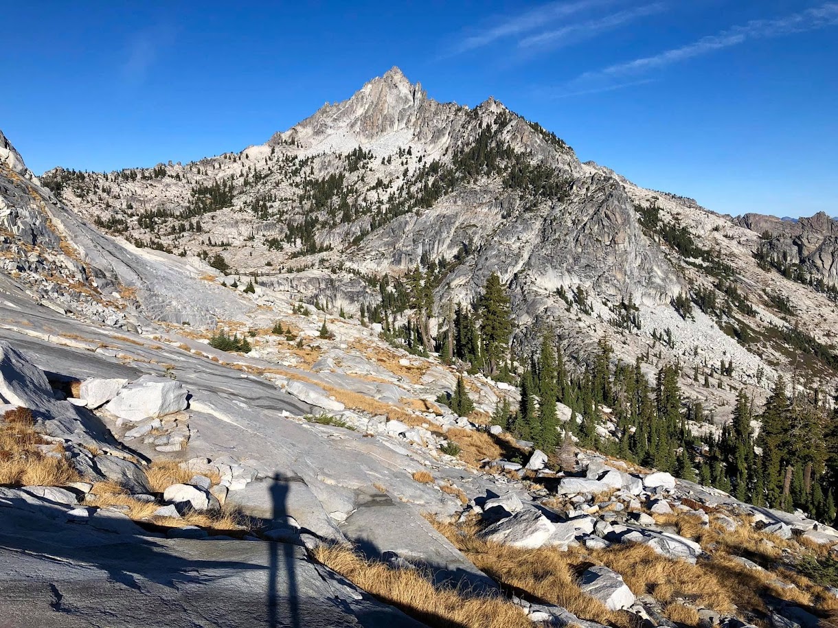
From Alpine Lake stay on the north side of the creek that drains the lake and look for a rudimentary passage through thick brush that ascends up and right toward the slabby granite slopes above. This section is rather unpleasant but short. Soon emerge from the brush and onto the glacier-polished granite which affords efficient access into the higher terrain above. Ascend the granite to the a high pass at ~7,800 ft with an excellent view of the upper Stuart Fork watershed and Mount Shasta. From this pass, make a descending traverse toward gorgeous Smith Lake. From above Smith Lake there are two options to reach the base of the scramble up Sawtooth Mountain: (1) traverse above and south of Smith Lake to reach Morris Lake and utilize a ramp to ascend up to a high col along the SE ridge of Sawtooth Mountain, or (2) descend to the outlet of Smith Lake and round the base of the SE ridge before commencing the climb up to the north side of Sawtooth Mountain.


Both routes have their rewards and if climbing as an out-and-back one can experience both of them. For the first option, head north from Morris Lake up a steep ramp and then veer northeast to reach a high col at around 8,000 feet to cross over the SE ridge of Sawtooth Mountain. The views from this ramp looking back to Smith and Morris Lakes is phenomenal. From the col, descend slightly to round a buttress and then ascend slabs and talus up to the base of the north ridge of Sawtooth Mountain. For the second option, after descending to the outlet of Smith Lake, make an ascending traverse across slabs and talus beneath the foot of the SE ridge and then make an ascent to the base of the north ridge of Sawtooth Mountain. The final slopes up to the base of the scramble are friendly granite slabs.


For the easiest scramble available, at the base of the north ridge climb a ramp on the east side of the ridge staying well off the crest. Difficulty will increase to class 4+ by staying on the ridge crest. Take the ramp to its end which places one on the NE face and then ascend class 3 rock up to a false summit. Sawtooth Mountain’s summit area is composed of several summit pinnacles but the pinnacle farthest south is the highest and contains the summit register. From the false summit moving south, climb over a pinnacle with rocks covered in black lichen. This step is nearly vertical but has excellent foot and hand holds. The next pinnacles can be avoided by descending and traversing underneath them, before commencing the final scramble up to the summit. From the lofty perch at the heart of the Trinities enjoy views west including virtually the entire Canyon Creek watershed from Mount Hilton to Thompson Peak. Immediately below Smith and Morris Lakes shimmer in the granite playground in which they reside. To the east is the entire Stuart Fork Trinity River watershed including Caribou Mountain, Sawtooth Ridge and the Red Trinities. Farther afield Mount Shasta looms on the horizon. It’s an amazing spot to soak in some of the most rugged and inspiring mountain terrain of the western United States. After climbing Sawtooth Mountain, one may continue on for further exploration on the Trinity Alps High Route.


Staggeringly beautiful photos, as usual, Leor. I wish I had a life to live again as an Alpine runner. I’d start training in my teens. It would so be worth it. Your photos take me there instead.
Valerie (Sierra’ Mom)
On Fri, Mar 29, 2019 at 12:16 Leor Pantilat’s Adventures wrote:
> pantilat posted: ” Sawtooth Mountain is positioned in the heart of the > Trinity Alps. As the name would suggest, the mountain is rugged from all > directions and is almost entirely composed of the glacier-polished white > granite that is characteristic of the region. While not” >
Way too hard for the benefit.
“look for a rudimentary passage through thick brush that ascends up and right toward the slabby granite slopes above”
Instead of “right,” it might be better to say Northeast. I wasn’t sure if “right” was a direction or being used like “right up until.” I ended up taking a very clear parting in the brush up a drainage that had many class 3 moves and it spit me out in the forest and not in the glacier-polished granite I was expecting. I hiked northeast from there and eventually found the granite area.
On the return, I found the cairned route through thick brush and found out the entrance from Alpine Lake was way further east than I was expecting. It would be difficult to know it’s that far east unless noted.
It’s a beautiful route and an extremely difficult day hike. But thanks inspiring me to take on this challenge.