Catching up on a route from July 4th that was a variation of the Sawtooth Loop I did back in 2013. The “Sawtooth Loop” is a spectacular route through one of the most scenic regions of the High Sierra and a personal favorite. I’ve come back to this area many times over the years and can’t seem to get enough of the scenery. I call this loop the Sawtooth Loop since it circumnavigates the impressively rugged subrange of the Sierra crest known as Sawtooth Ridge that straddles Yosemite national park’s northern boundary and the Hoover Wilderness. The base loop utilizes Horse Creek Canyon, Slide Canyon and Little Slide Canyon. This deeply serrated Sawtooth Ridge resembles a sawblade and contains features with enchanting names like Three Teeth, The Doodad, Dragtooth and Sawblade. Full photo album here.


 There are numerous variations and objectives in the region to include in the Sawtooth loop, including the aforementioned points along Sawtooth Ridge, Eocene Peak, Crown Point and Slide Mountain. The north side of Sawtooth Ridge is conveniently close to Twin Lakes and Mono Village, even allowing for straightforward access during the winter months. This area has numerous popular destinations like Barney Lake and Peeler Lake for hikers and the world famous Incredible Hulk for climbers. However, the south side of Sawtooth Ridge, located in northern Yosemite, feels remote and wild with comparatively a small fraction of the visitors. All of the canyons that surround Sawtooth Ridge are glacier-carved and spectacular with smooth granite walls and lovely meadows. On this day I chose to climb Matterhorn Peak and Finger Peaks, both summits I had climbed previously (Matterhorn several times) but the extensive snow cover from the unprecedented winter it made the experience different. In addition, this was an opportunity to climb Matterhorn’s east couloir again, my first climb in the High Sierra back in May 2007 (10 year anniversary climb!).

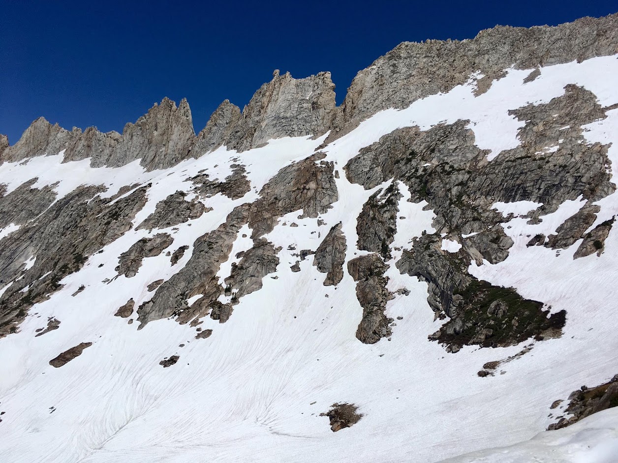 The loop starts at the Twin Lakes resort and ascends Horse Creek Canyon, first on well maintained trail and then a use path with wonderful scenery. At the first headwall, the trail disappeared for good under deep snowpack and it was time to put on crampons. Instead of continuing up Horse Creek Canyon, I turned right to head towards the Matterhorn glacier. On the way I passed a stunning ice pool with a light blue color and spent quite a bit time photographing this gem with the spires of Sawtooth Ridge in the background. From this tarn it was all snow up the snow covered glacier to the east couloir which made for an efficient ascent. The snow steepens in the couloir requiring ice axe and crampons. This is not a fun climb after the snow melts as it becomes a combination of loose rocks and gravel. I got to experience a bit of the loosness on the top 30% of the couloir which had already melted out. That being said, it was amazing how much snow remained in the region for July 4th. From the top of the couloir it’s a short climb with a few class 3 moves to the summit, with its wonderful 360 degree view of the region from Mount Ritter and Banner Peak to the south to Tower Peak to the north. In addition, alpine gold wildflowers were in full bloom and put on quite a show on rock ledges near the summit.

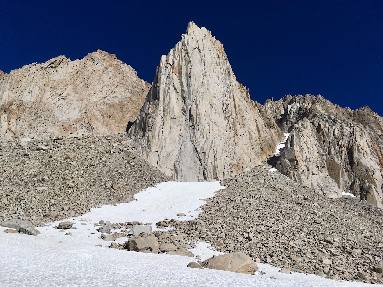
 A carry-over Matterhorn Peak, the highest point on the ridge, is an excellent way to access the outstanding scenery and wilderness of the rrapidemote region south of Sawtooth Ridge. The SW chute/slope of Matterhorn Peak offer a straightforward class 2 descent toward Burro Pass on the remote south side of Sawtooth Ridge. With the abundant snow cover I was able to angle over to the ridge descending from Matterhorn summit which separates Matterhorn Canyon and Slide Canyon and take that scenic ridge all the way to Burro Pass. From Burro Pass I traversed more snow to a couloir beneath the East and Middle Finger Peaks. After a moderately steep snow ascent the east peak is a short scramble. The East Peak has the best view of the ridge to Burro Pass and close-up views of Sawtooth Ridge. It also has an excellent angle on the precipitous east face of the Middle Finger Peak. Finally, it’s got a broad flat top which provides many spots for an alpine nap. A worthy summit despite being lower than the higher Middle Peak. After a nap I traversed around to the Middle Peak and climbed the fun class 3 route to the Middle Peak, including the improbable ledge that cuts across the face that keeps the climbing to class 3 versus a harder grade. The Middle Finger Peak is the highest and therefore has the best overall view of the region with the entire Sawtooth Ridge, Whorl Peak and much of northern Yosemite in view. After enjoying the summit I took the snow slope down between Middle and West Finger Peak to Upper Slide Canyon. This area has wonderful meadows later in the season, but the views of Sawtooth Ridge were equally impressive despite everything still snow covered. The heavy snowpack made finding the trail difficult so I went cross country for the most part. The approach to Ice Lake Pass included abundant, deep sun cups which were draining. Ice Lake was partially melted and beautiful while the Incredible Hulk was stunning as ever. Heavy snow in Little Slide Canyon made the descent quite a bit easier than normal as snow covered much of the talus. There was plenty of avalanche evidence with trees toppled over like toothpicks and deposited far down the canyon from where they once stood. Full photo album here.


Please label all photos beneath each one cannot ever figure out which is which from your blog!!!
Incredible photos, Leor! Such a beautiful loop!
Great shots. I just got back from the Sawtooth Wilderness (located, of course, in the Sawtooth range) in Idaho for the eclipse – that’s a place you would love with lots of seldom seen nooks and crannies – that is, if you haven’t been already. Highly recommended.