The Desolation Wilderness is the most rugged region near Lake Tahoe with the star attraction being Lake Aloha set amidst the granite slopes of the Crystal Range. Since it’s relatively accessible to Lake Tahoe, it is the most visited wilderness area in the United States per square foot. While there is no shortage of people on the trails on a busy summer weekend, I still found plenty of solitude in this granite playground during two visits to the Desolation this summer. In this first post I’ll cover the adventure run in July which entailed an aesthetic ridge route climbing the six highest summits in the Desolation Wilderness over 11h42m roundtrip out of the Mount Ralston Trailhead. The next post recaps a scenic and logical loop entirely on trails out of Bayview near gorgeous Emerald Bay done in late August. Complete photo album of the six summits loop here.
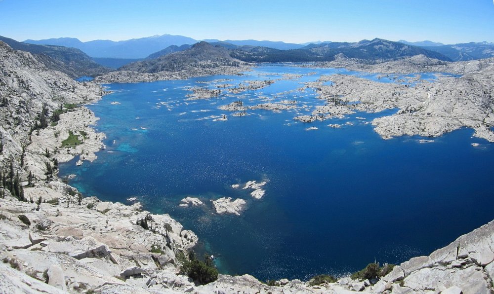
When looking at the map, a logical route links up the highest points in the Crystal Range from Pyramid Peak to Mount Agassiz to Mount Price. Jacks Peak and Dicks Peak are separated by the relatively low Mosquito Pass but they are close in proximity to each other. After descending to Dicks Pass from Dicks Peak, one can traverse a high ridge to Mount Tallac making for an aesthetic high route linking the six highest points of the Desolation Wilderness that is virtually all off-trail. I parked the car at the Ralston Peak trailhead and ran down Highway 50 to the Rocky Canyon use path. This path is steep and gains altitude efficiently reaching the meadow below Pyramid Peak quickly. The path continues up the last few hundred feet below the summit where there is some large boulder hoping. After enjoying the view from Pyramid and continued down the north slope and traversed over to a small section of rock scrambling. Continuing along the ridge and ascended a couple minor high points and then found myself on the slopes below Mount Agassiz. Mount Agassiz has an interesting summit pinnacle perched above Lake Aloha. From Agassiz, Mount Price is only a few minutes away running along easy dirt slopes. The descent from Mount Price to Mosquito Pass entails some downclimbing to a notch and then a long stretch of walking along slabs. The views of Lake Aloha from here are stupendous, with colors ranging from a deep azure in the deeper portions to turquoise. Eventually down at Mosquito Pass I crossed right over and began the ascent up Jacks Peak. It is on this ascent that that I found the most stunning views of Lake Aloha and the Crystal Range. Moving higher up the slopes, the birds eye view of the Aloha region was magnificent.
Unfortunately, the character of the rock changes dramatically north and east of Mosquito Pass. Instead of solid granite, the rock becomes progressively more fractured and loose. This makes for more arduous travel, but eventually I made it to the summit of Jacks Peak. From Jacks, Dicks Peak looks like a massive rubble pile (which it basically is). Fortunately, it doesn’t take as long as it looks to traverse between the two peaks. From Dicks Peak it was surprisingly time consuming to reach Dicks Pass and the high ridge between Dicks Pass and Mount Tallac proved even more time consuming. While this ridge starts out easy, it quickly transitions to loose shale. This stretch is not without its rewards as there are great views of Lake Tahoe on one side and Gilmore Lake on the other. I finally connected with the Mount Tallac and continued up the final slopes to the summit. I hadn’t seen many people to this point, but the renowned summit of Tallac had dozens of hikers enjoying the spectacular vista of Lake Tahoe. From this point to the finish was entirely on trail including a beautiful run along the shores of Lake Aloha. However, on the climb towards Ralston Peak I became dehydrated with no water available (note: fill up water before departing Lake Aloha). I was happy to crest the ridge and begin the long descent to the Ralston Peak parking area, reaching the trailhead 11h42m after setting out. Complete photo album of the six summits loop here.

Along the Ralston Peak trail I was not far from the summit of Ralston Peak, which would make for a seven summit day, but at 9,200 feet it’s substantially than the six primary summits of this route in both elevation and stature. Thus, I left Ralston for the next time I do this loop. Moreover, route knowledge will definitely allow me to go substantially faster on on the other parts the next time I attempt this loop. One major difference would be descending from Dicks Pass to Gilmore Lake on the Tahoe Rim Trail and then climbing back up to Mount Tallac. While this would diminish the high ridge nature of the route, it would allow for substantial time savings and perhaps completion below 10 hours. It is worth noting that water is scarce on the route, particularly later in the season, so plan accordingly.


Complete photo album of the six summits loop here.

nice. how many miles / elevation gain do you estimate for this?
hey leor-
nice. i did a similar loop about a month ago, starting at the glen aulin trailhead. i added ralston but figure the total miles were a little less than yours since i didn’t have to go all the way out to hwy50. did you record elev and mileage? would be interested to see how it compares.
here’s a hillmap of my route
http://www.hillmap.com/m/ag1zfmhpbGxtYXAtaGRychALEghTYXZlZE1hcBjLvC0M
Thank you for publishing these details within your website.